
If you were to drive to the far northwestern corner of County Mayo in Ireland, and then, just as you seemed to be running out of road, turned left, you might find yourself heading downhill to the sheltered cove of Rinroe Beach. Not far from this tiny strand is a graveyard. Or, to be more precise, two graveyards. The one nearest the beach is neat and square, with modern, polished gravestones packed in regimented rows. The other is older, its gravestones tumbled and strewn across a larger space, growing older and sparser as the graveyard extends towards a nearby stream.
It’s where that stream meets the graveyard that the mound sits. Taller than a man, it’s decorated with a few old grave markers, but exactly what it might be isn’t clear at first glance. I thought it might be some form of cairn, perhaps raised over the bodies of seafarers lost in a nearby Atlantic storm centuries past. Wikipedia suggests that it’s the remains of an early Christian church and resting place of St. Galligan, from whom the townland of Kilgalligan and the cemetery itself take their names. However, no one actually knows, as no archaeologist has ever investigated this remote mound. It remains what it first appears: an appealing mystery.

There’s much that appeals in this remote corner of Ireland. Myself and a friend (we’ll call her the SysAdmin) decided that if Covid-19 was going to isolate us, we might as well be isolated with a change of scenery, and so we rented a cottage (she did most of the organising) and drove there from Dublin (I did the driving). A four-hour drive, not counting stops, it was surprisingly uneventful for someone who is more familiar with the state of Irish rural roads as they were in the 1970s and 1980s. Whether due to investment in the Gaeltacht* areas (which Rinroe, Kilgalligan, and the village of Carrowteige in which we were staying form part of) or the more recent “Wild Atlantic Way” tourist promotion, serious effort has been made to make these areas more accessible than they once were.
Our AirBnB was a little way downhill from Carrowteige, with its single shop-cum-post office, and a little further uphill from Kilgalligan Cemetery and Rinroe Beach. It was while searching for the cottage that I first saw the cemetery, and I’d see it again multiple times as we walked past on the way downhill for an Atlantic dip or uphill while shivering. The mystery of the mound was never answered, despite the multitude of local stories that our AirBnB host had to share, but there was plenty nearby to explore.
One of the best stories he had to tell related to nearby Portacloy Head. There, on an exposed headland, a large ÉIRE marker had recently been restored. This marker was accompanied by a nearby number also marked out in white stone: 63. The name and number marked the site as one of Ireland’s Coast Watching Service, established during World War II (or The Emergency, if you were Irish at the time). The lookout posts aimed to watch Ireland’s coastal seas and skies, while the ÉIRE markers and numbers were to warn off planes (probably American) that might have lost their bearings. There were 83 in total, put in place during 1942–43, most along the west coast, but number 63 had one further twist: shortly after its restoration, part of Portacloy Head had tumbled into the Atlantic far below, taking a corner of the ÉIRE sign with it. We ventured up to see it, past some blasé sheep, and viewed both the marking and the gap where part of it had once been. It’s worth the trip for the view alone, but there are plenty of other markers to see around Ireland, some of them even quite close to Dublin.**
Over the three-ish days we had in Carrowteige, we did as much exploring as sea swimming and a desire for rest and relaxation allowed. Our trips usually began with us seeking out coffee for the SysAdmin (for SysAdmins need coffee in much the same way that the rest of us need air) but we ventured further onto nearby Belmullet, both north to the lighthouse and south to a rocky promontory where we found a stone spiral erected as part of a sculpture trail, where the peaks of Achill Island can be seen across the water.

Across the headland from Rinroe Beach, we found ourselves looking on the cliffs of Benwee Head near sunset. An Bhinn Bhuí, or The Yellow Cliff, in Irish, it towers over the Atlantic waves below, and the opposing promontory (the best place from which to view the cliffs) also hosts a sculpture of the Children of Lir that took abstractness in its representation to a whole new level. The cliffs themselves were more than enough to validate the visit on their own, forming perhaps the natural highlight of the whole trip. (And providing the header image for this post.)
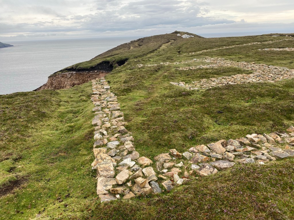
Further east, we found our way to the Céide Fields. Buried for millennia under peat bogs, near the strikingly striated Céide Cliffs, these unprepossessing stone walls are in fact as old as the pyramids and form Ireland’s most extensive Neolithic site and the world’s oldest field system. Covid had closed the nearby interpretive centre, so it was hard to get a feel for the extent of the site (only part of which has been excavated) but its story of deforestation, climate change, and population collapse struck close to home.
After all, Mayo has a far more recent history with depopulation. In 1841, a census marked the county’s population as 388,000. Twenty years later, following famine and emigration, this had dropped by a third. The population reached a low point of 110,000 in 1991, and even though it has since rebounded a little, it remains at just a third of its pre-famine population. Looking over the remoter areas of the county in a satellite image, it’s not hard to spot the shadows of old fields and walls, as well as the shells of old cottages and farm buildings, left empty by those who sought a better life, or just any life at all, wherever they could find it.
It’s not difficult to see why An Gorta Mór (The Great Hunger/Famine) hit Mayo so hard. The arrival of the potato as a staple crop that reliably produced food in small plots of land, even in cold years, had enabled a population boom in Ireland. The arrival of blight in 1845 removed that food source for the desperately poor farmers and the policy of the British government exacerbated the disastrous impact. If you’re interested in learning more, I can recommend the Irish History Podcast for its in-depth and even-handed series on a topic that still stirs hard feelings 170 years later.

Before we left, Mayo had one last brush with history to provide. As Storm Ellen barrelled towards us from the Atlantic, I told the SysAdmin the story of Oíche na Gaoithe Móire (The Night of the Big Wind). This tale I learned from my father’s love of history, and it dates back to just a few years before the famine. In January 1839, a mighty storm blew across Ireland, damaging buildings, costing lives, and leaving its mark in Irish song and story. Thankfully, Storm Ellen, though it rattled our windows all night long, wasn’t half so destructive, and we were able to pack up and leave safely when the morning came.
Covid-19 may have robbed me of any chance to travel to and across far distant countries in 2020. But it did serve to remind me that I have a car now, and a country full of sights I’ve yet to see at my doorstep. While I’m once more back in my own place and isolating as per normal, there are other isolated spots out there, and yet more sights to see. Whether or not you choose to start with Carrowteige and Mayo, it’s an option I’d definitely recommend taking.
* A predominantly Irish-speaking area. The Irish language, despite government efforts to support it, has long been in decline. Gaeltacht areas when I was younger were mostly known as the sites of summer holidays for children aimed at teaching them everyday Irish. How successful they were at that is questionable, but with more people than ever learning Irish online, there may be hope for the language yet.
** After years of neglect, there has been a rush of interest in these markers in recent years, and several of them have been restored. The Eiremarkings.org site is an excellent resource if you’re interested in learning more.
Cancer Update
One of the nice things about the trip was getting to be a little more active. Work keeps me seated most of the day, whereas sightseeing requires a little more walking. And sea-swimming required a little more walking and a lot more physical courage than has been asked of me lately. So I was happy enough to enjoy the benefits of fresh Atlantic sea air.

The trip began directly after a CT scan in St. James Hospital, and I got the results of the scan this Wednesday. The good news is that the medicine I’m on is doing its job—the cancer has been stopped in its tracks and has neither spread nor grown. I can’t speak for the effects of traipsing up and down Mayo’s peaty slopes, but I remain one of the healthiest-looking lung cancer patients you’re likely to ever come across.
It’ll be three months until the next scan, so I don’t know if there’ll be a health update with the next post. If there isn’t, I’ll probably be doing fine, keeping active as best I can and wishing I could get off on my travels at least once a day. Updates will continue though, as I’m thinking of extending my general disuse of Facebook into actually leaving that miserable platform. In which case I’ll just point people here if they want to keep up with me. No decision yet, but it feels overdue. Until then, keep well and try not to let 2020 get you down.
